There are 130 separate municipalities in Allegheny County, dividing up the county's 735 square miles in some unique, and in some cases historic, ways.
Like those boundary lines, some of these communities are anachronisms, struggling to maintain relevance and viability amid economic and cultural upheaval. Others are thriving beyond their ability to manage the amount of people, associated traffic, and service demands that are set upon them. Some of those demands spill over into other jurisdictions, requiring changes to the relationships between existing governments, or perhaps the creation of relationships where none previously existed.
This series is designed to illustrate and educate about some of the more interesting ways these boundary lines affect the lives and decisions of citizens, their leaders, and others who make our towns, counties, and state the place that it is - for better or for worse.
This time, I've found several examples of how shopping plazas, malls, and other similar areas challenge the assumptions we as citizens make about who has responsibility for public safety and other services.
Each illustration below provides a little insight, or links to it, into how a particular area became what it is today, and in some cases how the towns responsible for the area cooperated - or not - in the creation of these areas, and how their existence affects a community's quality of life.
There were more of these areas than I thought there would be, but it's not really surprising. In most cases, the involved towns are benefiting jointly from the revenue that their slice of particular retail pie is generating, which would kind of explain their existence in the first place.
There are also a few jurisdictional quirks unique to the Commonwealth that are near to and/or affect those who may frequent a shopping plaza. I've included some of these as well.
I focused on construction that occurred in the midst of a border line, instead of highways where development crept outward across a municipal, or even county boundary. There are plenty of examples of that (Cranberry, Peters Township, Hopewell) to go around.
Your insights are appreciated, as always. Have a great month ahead.

The "Grand-daddy" of area shopping malls, South Hills Village has been around since 1965, straddling the border between Bethel Park and Upper St. Clair. That line is a straight one, save for the inexplicable little jog in the middle of the mall. Both communities maintain their own separate public safety dispatch centers.
An extra added jurisdictional bonus is the Blue Line light rail station and adjacent Park and Ride lot and garage. Law enforcement for these areas is the responsibility of the Port Authority's Police Department. Credit: Bing Maps / John Linko
An extra added jurisdictional bonus is the Blue Line light rail station and adjacent Park and Ride lot and garage. Law enforcement for these areas is the responsibility of the Port Authority's Police Department. Credit: Bing Maps / John Linko

Crafton-Ingram Shopping Center
A lone testament to truth in advertising. The boundary dividing Crafton Borough and Ingram Borough runs right through the middle of the parking lot. Credit: Bing Maps / John Linko

Wexford Plaza
The shopping center's website describes it as "Wexford's main street for over 3 decades".
Considering that the center is split between two municipalities, and that Wexford is for all practical purposes little more than a mailing address, is it any wonder that there's an identity crisis going on here?
Nevertheless, it's interesting that the border of Pine and McCandless runs right through a little breezeway of sorts, as if the gap between buildings was made for it.
Also, the western boundary of North Park is adjacent to the complex. The Allegheny County Police are responsible for law enforcement there. Credit: Bing Maps / John Linko

The site of the former McIntyre Shelter for children, the property was sold by Allegheny County and developed in the early 1990's.
A key consideration for approval by the two townships involved was to assure that traffic could flow through the complex without additional negative impact on McKnight Road, AKA the "McKnightmare". This is probably why the access road through the complex connects McIntyre Road to Peebles Road. Credit: Bing Maps / John Linko
A key consideration for approval by the two townships involved was to assure that traffic could flow through the complex without additional negative impact on McKnight Road, AKA the "McKnightmare". This is probably why the access road through the complex connects McIntyre Road to Peebles Road. Credit: Bing Maps / John Linko
The Mess at "Robinson"
The massive commercial and industrial development starting at Settlers Ridge (bottom right) and extending to RIDC Park West (top left) is collectively referred to by many as "Robinson".
In reality, the complex spans 4 different municipalities, with public safety resources coordinated by 6 different dispatch centers.
This includes the limited access highway that bisects the complex - more about that in the next photo. Credit: Google Maps / John Linko
In reality, the complex spans 4 different municipalities, with public safety resources coordinated by 6 different dispatch centers.
This includes the limited access highway that bisects the complex - more about that in the next photo. Credit: Google Maps / John Linko

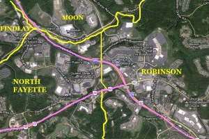
Exit 59 and Surrounding Area
Driving around in this area can give you a complex, especially if you need help. Knowing where you are can be a challenge, as the line between Robinson and North Fayette Townships basically divides the interchange, as well as the parking lot of Lowe's, just to the south.
If you happen to be on the Parkway or one of the on or off ramps (highlighted in pink), there's a bonus - law enforcement on limited access highways such as I-376 is the responsibility of the Pennsylvania State Police. Credit: Google Maps / John Linko
If you happen to be on the Parkway or one of the on or off ramps (highlighted in pink), there's a bonus - law enforcement on limited access highways such as I-376 is the responsibility of the Pennsylvania State Police. Credit: Google Maps / John Linko
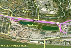
The Waterworks - How Not to Do It
A lot of people think that when they're shopping here that they're in Fox Chapel or O'Hara Township - heck, even the company that built the place thought so.
Surprise - the mall, adjacent UPMC St. Margaret Hospital, and the Pittsburgh Water Plant across Freeport Road is actually a somewhat solitary outpost of the City of Pittsburgh, surrounded by the above communities, as well as Aspinwall. The State Police are responsible for nearby Route 28.
The associated traffic, crime and other impacts, without any say in planning or sharing in any of the tax revenue that the City enjoys, was something that had these neighboring towns bristling a bit when the complex was first opened.
Whether or not the situation has improved is unknown, but one thing appears certain - cooperation and coordination didn't appear to be a priority from the start. Credit: Bing Maps / John Linko

The Waterfront - Making the Best of It
In contrast, redeveloping the land that hosted the historic, mammoth Homestead Works could have been a significant challenge for the three towns that hosted the steel plant. But as Wikipedia notes, "The Waterfront was predominantly a private investment, although there was a tax increment financing of approximately $25 million approved by three separate municipalities, one county, and one school district, a notable accomplishment".
While the complex's sprawling size and lack of pedestrian walkways in many places makes getting around it a little tough, there appears to be a commitment by the towns who benefit from it's operation to keep it safe and attractive to residents across the region.
The complex employs private security that interfaces regularly with the three municipal police forces. Additionally, officers from those departments provide dedicated patrol of the entire complex during peak periods - without regard for jurisdictional boundaries.
Munhall still maintains its own dispatch center, but the level of cooperation between them and neighbors Homestead and West Homestead remains good. It's not perfect (what is?), but it's a step in the right direction. Credit: Bing Maps / John Linko
No comments:
Post a Comment